Showing posts with label #Soaring. Show all posts

Tuesday, June 20, 2023

Excellent June Soaring (Ridge Runs)

Around Wednesday, I got a clue that the upcoming weekend was going to be an absolutely amazing soaring day.  A cold front was scheduled to pass on Friday night, leaving cold air, and a brisk northwesterly wind.  These two factors meant that this is going to be a great soaring day.  The best part of all -- this excellent soaring day was going to happen on a Saturday, and not on some random Tuesday. 

Not only was the weather going to be great in Virginia, the winds and air aloft was predicted to be a great soaring day all the way up into Pennsylvania, too. This could be one of those rare days where the soaring is great all the way into the ridge system in Central Pennsylvania.   I had to start looking for a copilot. 

I asked two people who had previously indicated that they were interested in doing a cross-country soaring adventure with me.  Both of them were scheduled to be out of town. This caused me to expand my search.  I asked a glider pilot who lives in Miami, FL if he would be interested in joining me.  Nelson Brandt had indicated that he would drop everything and show up for a good ridge adventure, so I asked him about his availability. 

Nelson dropped everything, and found a flight to DCA on Friday. I have a spare room in the house, so he spent the night.  We woke up early, and got to the field by 0800. The glider was assembled by 10:00. The tow pilot reported that conditions aloft showed strong northwesterly winds, and even that the tow plane could soar on the ridge. What a great start! 
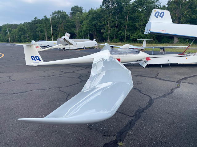

QQ is assembled and ready for flight by 10:00 A.M.

I had come up with an ambitious task to take advantage of the great soaring conditions.  The plan was to launch from Front Royal as early as we could get aloft; somewhere before noon would be preferable.  The task starts at the southern end of the Massanutten mountain at Laird's Knob.  From there, we would head north along the Massanutten ridge, find some thermals, and cross terrain using thermals for lift.  The goal was to get to Dickey's Mountain in Pennsylvania. At that point, we could scream along the Tuscarora mountain past McConnellsburg, PA.  We could make a transition to Shade Mountain, and go to the planned turn point on Shade Mountain near Snook airport (PS06). Then we'd turn around and come back. The whole trip was planned to be 560 kilometers out and return. We would get more credit on OLC for the trip down to Laird's Knob to start, and the trip back from Laird's knob after the finish. 
The night before included preparation by measuring 60 liters of water for the wings, and another 15 liters of water we'll use for adding tail ballast. I put the water into 20 liter jugs, so we didn't have to spend valuable time measuring water in the morning. Adding water will get the mass of the glider much closer to the maximum gross weight. This allows us to fly faster when the conditions are strong, and have a smoother flight while on the ridge.  We'll add water to the tail to make it easier to center thermals, while we're not ridge soaring. Last year I wrote a Microsoft Excel spreadsheet to calculate and display the weight and center of gravity, when programmed with pilot weights, oxygen bottles, liters of water, etc. 

Loaded with 60 liters of water in the wings, we're going to be heavy!


Adding 11 liters of water to the tail before takeoff

We launched just before noon.  We headed straight to the northernmost portion of the Massanutten mountain, to a location named "Signal Knob".  We flew along the ridge, and it seemed like it was working well.  We descended down to 2200 feet MSL, and I started to take note that the flight computer was reading a wind velocity of 6 knots at ridge top height.  I spent some time doing figure 8 motions where the lift was stronger.  Maybe the winds weren't strong enough yet? 
Also of note was the fact that the visibility was terrible. I hadn't seen any prediction of such poor visibility in the forecast.  It was hard to see more than about 5 miles down the ridge due to smoggy haze. 
We made it down to Laird's Knob near Harrisonburg, VA.  There, we turned around, and I had increased confidence that the ridge was working.  As we approached the part of the Massanutten where route 211 passes through the mountain, I made some figure-8 turns to gain height. 

By the time we got back to Woodstock, VA, a hang glider launched and was soaring in thermals.  We joined him for a short bit. 
After getting past the Massanutten, we blundered out into the hazy smog, looking for thermals. 

Satellite photo of the clouds at 14:00

14:00 By the time we got north of Winchester, we were way behind my time plan. I really wanted to launch earlier, I really wanted that ridge lift on the Massanutten to be more reliable, I really wanted the thermals to be stronger by this point.  I was starting to get anxious that the day was going to run out of soaring while we were still far from home!  

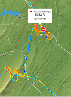
We found some marginal thermals -- one near Gore VA -- that got us closer to the West Virginia border. We headed north and finally found a thermal that gave us a really comfortable altitude of around 6000 feet MSL. The valley in front of us didn't have as wide a selection of suitable landout fields that we can usually find in the Shenandoah Valley.  This wasn't treacherous terrain, though. 

A few more thermals got us to within gliding range of Potomac Airpark, which is right across the river from Hanover, Maryland. I knew once we had a good altitude over the Potomac river, we could easily connect with the Pennsylvania ridge system. 

The winds had been really reducing our speed for all these thermals.  For each thousand feet we climbed in a thermal, the wind would push us 5 or 6 miles perpendicular to our course.  It would be a really welcome change to have a high ground speed, instead of inching along with thermals. 

By 3 PM, we had finally reached the southern end of Dickey's Mountain, and the Tuscarora mountain ridge behind it was sure to be a great ridge run at 100 to 110 knots. It did not disappoint! 

Tuscarora Ridge Soaring

We were way behind on my time plan. I was growing increasingly nervous about how we weren't as far along as I had hoped.  Back on Friday, when I was planning this flight, SkySight told me that the task was impossible considering the conditions. I was starting to wonder if the software was right!

The task I had planned included one transition to an upwind mountain range.  This is a place where I would need a thermal to get high enough to go up wind and connect with Shade Mountain. Unfortunately, by the time we got to that part of the ridges, things were not looking so good.  The haze had set in, there was a really thick cloud over that area. We had no idea how the conditions were ahead on Shade Mountain. 
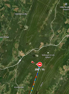

Sat Photo of the terrain for that transition

Sat photo of the cloud conditions when we got there

It just didn't look good.  I really didn't want to get stuck on Shade Mountain for the rest of the day.  I really didn't want to have to land out at the bottom of one of those mountains. (The fields around here are quite landable, and I would have made a safe landing for sure).  We had another 60 miles to go on the ridges to get to the turnpoint.  We had another 60 miles to get back.  At 100 knots (a very realistic speed), it would take us nearly an hour to get back to this point on the ridge again.  And who knows if the conditions are going to allow for a thermal to jump back from Shade Mountain to the Tuscarora?

I decided to turn back.  You know, we had already made an excellent trip up here, and the conditions weren't looking that great up ahead. I stand by my decision. Now we just had to get home!  This looked like it was going to become increasingly difficult. 

We headed south on the Tuscarora back to Dickey's Mountain. There, we would have to find some sort of thermal to get off of the Pennsylvania ridges. The thick layer of clouds above looked like they were going to shut off the thermals for sure.  Maybe we will be landing in Pennsylvania, after all! 


Once we got to the bottom of Dickey's Mountain, we faced the challenge of climbing up to escape the ridge system. At first, there was no real lift to work.  We needed to hang around for a bit to find something strong enough to get us high.  The overcast wasn't helping. I took over and performed some figure 8's in front of Dickey's Mountain.  We noticed a nice cloud had formed over the track we just flew under. Given the wind strength, there was no way the mountain we just flew along generated that lift, it had to come from a source upwind. 

I took the glider upwind on the other, smaller ridge, and found a great strong thermal to get us out of that mess. By the time we got out, the thermal had gotten us from 2900 feet to 5300 feet, and we had made our escape to the East. 
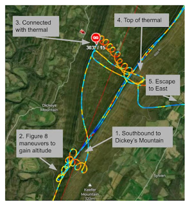
Our escape from Dickey's mountain required a strong thermal on the upwind slope

Once we successfully escaped from Dickey's Mountain, we still had a long way to get home. Dickey's Mountain is 55 miles away from the Front Royal Airport, and things aren't looking that great. There are a few clouds in front of us, but all of the clouds to the left of our track (to the North) look like total garbage. In the meantime, the radio chatter from Mid-Atlantic Soaring in Fairfield, PA is asking their duty officer to check for radar echoes.  The grey clouds looked ominous enough to them to make them wonder if some rain showers were developing. 
Since our task of going to Snook and back was canceled, maybe we can scrounge a little bit of glory back from this flight by landing at M-ASA and getting the Boomerang trophy... again.  We tune the flight computer, and at one point, we were 500 feet below glide slope to make it to M-ASA. After hearing the negative words from M-ASA, and seeing the yucky clouds, we make a right turn to continue heading home.  But that takes us right over the Hagerstown Class D airspace. 

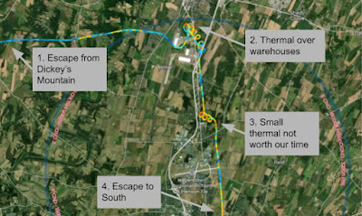
When we got to the airspace around Hagerstown, MD, we got down to about 3700 feet MSL.  The Hagerstown Class D is at 3200 feet.  In order to get into that airspace, we needed to establish radio contact with the control tower. I looked up the frequency in the flight computer. Nelson called the control tower and got us clearance to transition the airspace if necessary, as we transitioned south. We found some nice thermals over  some warehouses.  We got a good look at the airport as we crossed nearly overhead.  There was a DHL cargo plane parked on the ramp, and there were a few fire-fighting airplanes that I didn't get a good enough look at. 

We found a thermal to the south of Hagerstown, MD.  It is very likely that this thermal was generated by the Maryland Correctional Institution, or the Roxbury Correctional Institution.  By looking at the circles we flew, it sure does look like the solar panels they have in the southwest part of that property are what kicked off that thermal.  

Somewhere around here, I suggest that the thermals haven't been that good lately.  Maybe we should dump the water ballast so we can work the weaker thermals.   Of course, once we dumped the water ballast, the thermals got much stronger. We dumped the water at 16:23, according to the flight logs. Four minutes later, we find a great thermal right over the Potomac River. We climbed from 2600 feet to 5640 feet in a matter of 10 minutes. I had some time to look at the scenery, and I noticed some kayakers on the Potomac river below. It had been over four hours since we took off, so I took advantage while Nelson was flying.  Nelson was doing the circling while I was... uh... dumping my own water ballast. Sometimes it's really good to have two pilots on-board for these long flights. 

Things started getting easy again.  We had escaped the overcast yucky skies to the north, and the thermal clouds are looking better.  The visibility was improving. I could just barely make out the Massanutten mountain at Signal Knob about 15 miles away. 

"Do you really want to land back at Front Royal, or do you want to run the ridge again?" 

Of course Nelson said, "Yeah! Let's run the ridge again!" 

We made Signal Knob at 2400 feet MSL, just slightly higher than the mountain.  Yep. The ridge was working, and it was working well. Unfortunately, we didn't have any water ballast, so this ride was a bit rougher than the ride along the Tuscarora a few hours earlier. 

Nelson did the ridge run southbound, and I took over once we passed the turnpoint at Laird's Knob. On the way back northbound, Nelson got out his iPhone and started recording.  We had a great video of the glider's shadow on the mountain.  As we approached Route 211, I spotted some hikers on the Yellow Cliffs Mountain Overlook


While I'm doing all the flying, Nelson made a time-lapse video of the ridge run on the northern part of the Massanutten.  You can see from this video the transition across Short Mountain. 


We safely landed after 6 hours and 48 minutes of flying. What a day! 
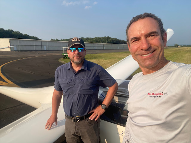
Piet Barber (left), Nelson Brandt (right) after almost 7 hours of flying

I'm happy that the ground crew stuck around to help us put the glider away.  We spent another 45 minutes cleaning the wings, taking the wings off, putting the fuselage back into the trailer.  I wear a special apron when I'm assembling and disassembling the glider. 

Another safe put-away after a day of soaring!

Post Flight Analysis: 

  1. When we were coming back, I don't know why we didn't use the Blue Ridge Mountains to the east to ridge run back to VA.  We probably could have spent an hour less time circling over Hagerstown, Martinsburg, Winchester.  The transition back upwind to Signal Knob might have been challenging.  On the other hand, we could have continued down on the Blue Ridge until we got to Interstate I-64. 
  2. I think the next time, I'll spend more time looking at the ridge lift near Berkeley Springs, WV. I think we could have cut down on some of the thermal time by doing some ridge lift before jumping across the Potomac River. 
  3. In retrospect, it looks like the clouds just beyond the jump to Shade Mountain meant that we could have very easily continued the journey to Snook (our intended waypoint). I didn't know this at the time.  Maybe we should have pulled up the sat photo on ForeFlight before making the decision to turn back. 
  4. I need to clean the canopy before flying next time.  I can see dust accumulated on the canopy in the GoPro videos. 
  5. I really need to find a better way to mount the GoPro in the cockpit.  A lot of the GoPro footage was ruined by Nelson's big hat. 
  6. Nelson flies with a hat in his lap to keep the sun off of his hands.  That's weird, and makes the video of him flying look weird.  Why is your hand under your hat in your lap? Sheezh. 
  7. Nelson and I get along really well in the cockpit, and have similar thoughts on the decisions we make. 
  8. I'm getting better about only turning to the left when I thermal. Doing right hand turns really helps with the GoPro footage when the camera is mounted on the right side of the canopy. 
  9. I have figured out how to find when the flight computer records the change in mass due to dumping the water ballast. Just do a search for the word "wet" (in lower case) in the IGC file. 
  10. The next time I do a plan like this, maybe I should stay on the Tuscarora ridge, instead of doing the difficult transition to Shade for no appreciable difference in miles. 
  11. We had the 11th highest score in the US for Saturday. We had the highest score east of the Mississippi River. All of the other OLC pilots in the USA had flights out of Region 9 or Region 12 (Warner Springs and Parowan)
Flight Log Links: WeGlide / OLC / SeeYou.Cloud


Monday, March 13, 2017

Winch Training at Eastern Soaring Center


Recently, a commercial gliding operation has opened up within a [relatively] short driving distance from home.

Eastern Soaring Center has opened for business.  They offer a dedicated environment to help students work on all of the fundamentals of soaring, except for aerotowing.

This operation is run by Brian Collins. Brian is retired Air Force. He has been flying gliders since his days at the Air Force Academy. He has been giving glider instruction at many different glider clubs across the US, including the Civil Air Patrol encampments in Mattoon Illinois. In 2013, Brian was also the first or second US citizen to get the 1250 kilometer distance flight badge.

I made an appointment to get my winch launch certification.  I've never done a winch launch before, and I've never seen a winch operation in action before.  Back in the old days, most glider pilots had the words "Glider - Aero Tow Only" printed on their pilots certificate.  In 1997 this certification was obsoleted.  Since 1997, all you need is a logbook endorsement for any of the launch methods: Aero-tow, winch, or self-launch.

For all of the 1800 glider flights I've done in the past, it's been on the end of a 200 foot rope connected to an airplane with a strong enough engine.  The acceleration on takeoff is slower than the acceleration you'd experience in a car merging into traffic on a freeway.  Once the glider has enough airspeed, the glider gets airborne usually just before the tow plane starts to climb. The tow plane and glider climb to release altitude, where the glider pulls a release knob, and lets the tow plane go. This usually takes about 6 minutes to climb to 3000 feet.

In contrast, a winch is a power plant that stays on the ground.  Hook up a 300 horsepower engine to a spool of 5000 feet of cable on one end.  Hook up the glider on the other end.  When the glider is ready, gun the engine. The majority of that 300 horsepower is dedicated to the glider's acceleration.  Within 1 to 2 seconds, the glider is off the ground.  Within 40 seconds, the glider has climbed to its highest point, and released to start its free-flight.

Eastern Soaring Center's Winch. The pickup truck is a mass anchor that helps keep the winch in position.

When launching with the winch, the acceleration is really hard to describe.  The closest thing I can use to describe the acceleration is when sitting in a Tesla that is accelerating in ludicrous speed mode. After the slack is taken out, the winch's engine RPM is gunned to maximum. The glider has accelerated to flying speed within 1 to 2 seconds.

Eastern Soaring Center's Twin Lark climbs out on a winch launch
The next 2 to 5 seconds, the glider increases its climb angle.  Not too quickly, and not too slowly. Too quick of a increase in pitch, and the glider risks having an acceleration stall and crashing into the ground.  Too slow of an increase in pitch and the glider doesn't climb as well.
This critical phase of the launch is also when a break of the rope could be disastrous. If the rope breaks, the pilot must immediately recognize it and immediately lower the nose well below the horizon.  We practiced this emergency release several times at varying altitudes.  Here's a video of one such break, from the Netherlands.

In the United States, a winch launch is a relatively rare procedure. This is much more common launch method in Europe. The British Gliding Association recently had a safety initiative to improve the safety record of winch launching. After their initiative (Safe Winch Launching at the BGA's website) the accident rate dropped significantly. The safety record of winch launching has improved to a lower accident rate than what is seen with the aerotow launch method.

One of the best advantages of the winch is the lower operating cost. With an aerotow, all of the glider pilots who use the tow plane for launches are sharing the creeping costs of the tow plane.  Every hour the tow plane flies, it is ticking ever closer to the eventual overhaul.  Every airplane that has an engine needs to have its engine removed, and essentially is totally rebuilt every thousand or 1500 hours.   Also adding to the cost of an aerotow is the training required for a tow pilot.  The cost is mitigated by using a volunteer work force in a club environment. At a commercial establishment, the tow pilot is going to expect to be paid. The cost of fueling the tow plane is rather unpredictable. Fuel that is suitable and certified for an airplane is much more expensive than the fuel you use in your car.

The advantage I'm most interested in is availability.  Sometimes I see the weather forecast and know that it is going to be one of the best flying days of the year.  Unfortunately, that day is a Tuesday. One of the disadvantages of being a weekend-only flyer is that there is a poor chance that the good flying day is going to end up on a weekend. About 28% chance, that is.
Sometimes the really good flying days mean exciting takeoff and landings for the tow pilot. While I only have to endure one take off and one landing on the really good flying days, our tow pilot must subject himself to as many takeoffs and landings as there are brave pilots willing to fly that day.  Sometimes when I come in for a landing on those days, I'm just happy I made one landing.  To think that the tow pilot has to do this a dozen times on these days is commendable. Many times, the tow pilot will cry "uncle" after a few launches, when conditions are too sporty for him.  While there are times the winch operator is going to call it quits because of sporty flying conditions, I don't think the number will be as high.
Eastern Soaring Center's Twin Lark is ready for
launch (yes, without a wing runner)
There were only three people involved in this operation. The winch operator, the instructor, and me. For all winch launches you need to have a wing runner. If the glider's wingtip ever drags into the ground, the glider violently cartwheels and is destroyed.  These sorts of accidents are often fatal. The only solution is an immediate release of the rope.
To do this operation without having a wing runner, Brian created these cool wing skids.  They are the right height, covered with soft carpet, and steady the wings better than a wing runner can.

After 9 flights with Brian, training me to do a winch launch, he was ready to solo me.  We had covered all of the emergency procedures. We practiced most of these, varying from 20 feet of altitude to 400 feet of altitude.  Depending on the point of release, we would do S turns, a 360, or a straight ahead landing after the rope break.  Brian let me go for a solo flight, and I was excited as I was when I had my first solo at age 15, back in 1988.
On the second day, Brian and his son Marshall worked to get me 5 solo flights in the Twin Lark. The airfield at Petersburg is long enough to stage the glider at 2/3rds down the runway.  I launch to a satisfactory altitude of 1700 feet above the ground. I circled around, landed, and stopped within 10 feet of the previous launch.  Brian hooked me up, and I was off again.  I've never done 5 takeoffs and landings so quickly before!
My next challenge is to do a winch launch on a good ridge day, and then go out and do a diamond altitude climb ( 5000 meters of altitude climb, 16,404 feet), or a 500 kilometer diamond distance course.  Now that I'm checked out, I'm looking forward to the challenge.
I'm going to recommend that some of my students come visit Brian. Especially the students who can't figure out that last few moments of flying phase.  If you need landing practice, doing the winch launch is a great way to pound out some flights really quickly.


Monday, August 8, 2016

Sunday's Post-Flight Analysis


Dear Steve,

I get a lot of information about my flying by doing an intense post-flight analysis after every flight. 
I grab the IGC file from the PowerFLARM or the Nano, and upload it to OLC.  Our flight on Sunday was a really interesting flight with some low saves. When it's a really interesting flight, with some low saves, I'll convert it to a KMZ file to look around at the fields I was looking at in flight.  This builds a collection of off-field-landing insights that adds to my repertoire.  

Follow along with me.  

Download this KMZ file 

The OLC has an IGC to KMZ conversion program, but it's kind of ugly.  They don't include many points on the track, and there's no detail about the thermals. I made the above KMZ file with a program I wrote, that's hidden on the members-only section of the website.  I wrote it before OLC was a big thing.  I had grand visions for it, integrating into our instructional program, but those visions faded away. You can convert IGC to KMZ with the link:
http://members.skylinesoaring.org/TRACES/

Pull up the KMZ file in Google Earth. By default, the Google Earth shows everything in an absolute top-down view.  I find it more useful to look at the flight in a somewhat oblique angle.  View everything at an angle in Google Earth by holding down the Alt Key (Windows) or Command Key (Mac), while moving the mouse around on the screen with the left mouse button clicked.  Zoom in and out with the Mouse Wheel.  Once you get a feel for navigating around with Google Earth, go find our low point, which was next to the town of Tenth Legion, VA.  Each of those blobs are clickable, with the information that was recorded in the IGC file for that datapoint. 

During our Sunday flight, our low point 2178 feet MSL (!)

The field we were looking at -- the one that's at Tenth Legion -- looks like it definitely would have been long and flat enough for us to land in.  I wonder what the story is for this field. 
The field is at 1100 feet MSL, at 38º34'35.68"N 78º43'35.66"W. 

You can use the ruler tool in Google Earth to give you an idea about relative distances. Use it to draw a line on the ground, and it'll measure the distance over the terrain.  Let's see if that field sucked, or if it really was long enough for an outlanding. 


According to Google Earth's measurement tool, it's 1200 feet by 85 feet. 
It's a good thing that we found this thermal when we did! My "We gotta land if this doesn't work out" spider sense turned out to be right.  We were down to 1100 feet AGL over this field I was favoring. 

Let's take a look at the field you were looking at: 38º33'43.45"N 78º42'22.97"W
Hey! It doesn't look too bad!  It looked kind of lumpy to me from the air, but the altitude differences weren't that much around the field.
You can figure out the elevation of the terrain by moving your mouse around and looking at the readout for altitude on the bottom right of google earth.


The other low save wasn't nearly as low; even though we were in an interesting position. On the Eastern side of the Blue Ridge, near Syria, VA.  Low point of 3100 feet MSL. The mountains immediately underneath made it look lower than we actually were.  We had a lot of distance we could cover to find more lift or a landout field. 

While we were seeking that solid thermal to get us out of that mess, the field I had in mind looks pretty good. 1600 feet long, but complicated by trees on the approach.  The trees would reduce the usable length of the field, so that's a demerit. 


Landing it on the diagonal would have given us another 200 feet, which is what I probably would have done. 


There were many other options slightly to the north, between Peola Mills and Etlan, VA; just east of Old Rag. 


Here's the crummy photo I took from the iPhone when Romeo-Whiskey was turning too much for a good photo.  I couldn't get out the phone in time for us to fly with the Bald Eagle over Front Royal. 


Finally, there was a really really bright light that distracted us for a while.  What the heck was that light? We wondered if it could have been a helicopter with a landing light on it, pointing right toward us.  We flew toward it, I turned to the side, and there was no horizontal relative motion; then I turned back toward it.  The lack of horizontal movement means it was really far away. Shane quipped "It's a fishing lure", and Chuck suggested it might be that laser that they use to tell an aircraft that it's flying toward FRZ airspace. 

I found the part of the flight trace and projected the distance out.  
Projecting the distance out... it's pretty much right over the middle of the city.   I wonder if it was a building that was just pointed out the right way, reflecting all of its glass at us, or if it's really something more laser-y.  It's conceivable that it was a building in Rosslyn. Not likely to be Tyson's Corner. It could have been a glass building at Reston Town Center. 

I don't think it was the FRZ laser system.  That's supposed to flash red-green-red-green.  This was a solid bright yellow-ish white. 

I bet it was some perfectly aligned building. If I had some photos of the light, I could probably figure out which building it was with some triangulation, while using the GPS information. 


One of the cool functions of OLC is showing where you were flying with other gliders nearby.   Here, on our flight trace, you can see Romeo Whiskey following us along the blue ridge, and November Golf flying around us after we flew with that Bald Eagle over the town of Front Royal.


I hope you enjoyed the flight and found it to be educational and memorable. I hope it gave you some sort of idea why cross-country soaring is so much fun -- way more fun than grinding about, around the pattern all the time. 

Tuesday, December 29, 2015

Video along the Ridge

A few days before Christmas, I got to take some friends along the ridge for some flights in my Duo.  One of the passengers, Craig Sutherland -- documented the flight with his hand-held GoPro.

I also mounted my GoPro, but didn't look at the settings closely enough when I mounted it.  I have 5 pictures stored from my GoPro; each time a nice picture of me fiddling with my cell phone trying to get the video camera to start recording.  I guess I need to work on that technique a bit more.


Friday, October 23, 2015

Saturday Soaring with Keith

With a brisk northwesterly wind in the forecast for the weekend, Saturday and Sunday were both shaping up to be a great weekend to be a glider pilot.  I wrote one of my former students, Keith, if he wanted to go ridge running with me in the Duo Discus. He quickly accepted the offer.
We arrived reasonably early, assembled the glider, and spent some time trying to figure out why the SN-10B still isn't talking to the NANO III flight computer.  Several things were pried open, checked out, and still no firm conclusions as to why the NMEA input isn't making it into the SN-10.  That's still on the things I need to get solved on my new glider.  The flight computer has limited functionality while there's no GPS feed, and I can use maps and the tiny visual display on the Nano for navigation.
Once airborne, I got the glider down the ridge.  We were the so-called "Ridge Dummies" -- the first glider up for the day, to test out the wind direction and strength on the ridge.  Once I confirmed that the ridge was working, I called back to home base, reporting that the ridge was working. We maintained 3000 feet at about 80 knots along the top of the Massanutten mountain range.  For a short while, we met up with 3 or 4 hang gliders, launching out of the Woodstock Hang Glider launch area.
The day was also shaping up to be good for thermal activity, too. I followed a street westbound, and crossed over the Virginia / West Virginia border.  We passed north of the Bryce ski resort, and I even got far enough west that I had the Grant County airport in sight. As we continued west, the thermals got more sparse, and had less strength. We descended from the comfortable 6500 feet down to about 4000 feet as we searched for lift.
Whenever I'm flying with somebody, I often ask them, "Still having fun?"  "How are you doing up there?".  Keith responded through the flight with enthusiastic rapid responses, "Doing great!" "Really enjoying myself!" As we approached our westernmost point, with ever decreasing altitude, I asked again:
"Still having fun?"
There were a few moments of nervous silence coming from the front seat.  "I'd really like to see the needles pointing upward" Keith was growing ever more uncomfortable with our situation. His comment indicated that he would rather we be in lift. The safety of flight was never in jeopardy: there were some magnificent, large fields 2 miles to the northwest, next to the town of Lost City, WV. If somehow the thermals abruptly stopped producing lift, that field next to the town center would have been longer and wider than the airport we took off from. We also still had plenty of altitude to make a downwind dash across the Shenandoah valley back to Short Mountain, next to Mount Jackson, VA.
I connected with the thermal that I was sure was located under a white puffy cloud, and climbed back up to a comfortable altitude.  Soon, we were headed west again, back to Short Mountain.
On the way toward Short Mountain, we hit a very minor small bit of turbulence. I heard a very loud noise. "CRACK!" It sounded like a lead weight had fallen off of a table, and slammed onto the bottom of the back of the fuselage.  Since I was in the back seat, it was especially loud.   I had a few moments of cautious discomfort, with images in my mind of the empennage suddenly disintegrating behind me; pieces of expensive fiberglass and carbon fiber departing the aircraft.   The controls still worked. Keith and I talked about it briefly, and got on with the flight, after determining that the aircraft was still apparently intact.
We did ridge soaring down to the southern end of the Massanutten mountain system, in close proximity to the Massanutten ski resort.  I stopped at a waypoint called "Laird's Knob", where Keith got out his camera to get some great pictures of the fresh fall foliage on the nearby mountain.
Just above the ridge top, where you can see the radio tower. Laird's Knob

Laird's Knob, and radio tower


Laird's Knob, radio tower, gravel rockslide; where there are no trees

After hanging out over Laird's Knob, I followed a cloud street eastbound, where the clouds looked best.  We connected with an incredibly strong thermal, and climbed at 900 feet per minute to as close to cloud base as I could legally get. We were so amazed about the 9.9 knots shown on the flight computer for average lift, that I had Keith take several pictures.  Unfortunately, the peak strength of the thermal was a few moments before this picture was taken.
The "8.9" in the upper-right corner of the flight computer indicates the upward velocity averaged over that last 30 seconds, in knots
The thermal was so strong, I asked Keith, "Hey, we could go down to Waynesboro!" The conditions were really that strong. Keith instead opted to go north, back to home base. We had been up for 2 hours, and I guess he was getting cold.

Along the way, we got some nice photos of Skyline Drive, along the Blue Ridge mountains.  It's near peak foliage, and Skyline Drive was packed with "LeafPeepers" -- tourists who wanted to see the National park in all its glory.

Looking North, towards Thornton Gap

That looks like an excellent thermal over there!

Looking East, towards Culpeper, VA

After a glorious flight along the Blue Ridge, where we just bopped along at altitude, without stopping to work lift, we did a final glide back to the airport.  By the time we landed, things were getting pretty overcast and grey.  The weather was much colder.
Final glide back to the airport, overhead at about 2400 feet MSL
Keith recorded my approach and landing.  We had a crosswind coming from the right on final, and I think I did a pretty good job practicing a side slip to attain runway centerline alignment.  I'm still trying to figure out how to land this new glider of mine. :)


Back on the ground, safe and sound!
 During the post-flight inspection, I determined the cause of the sudden bang in-flight. I don't normally seal the wing root with the fuselage on this glider.  The previous owner did a great job of sealing the joints with some foam.  This way, the air won't leak in between the fuselage and wing root, causing whistling noises in-flight.   One of the pieces of foam has come loose, and it causes the glider to squeak in some particular attitudes in flight.  So this flight, I taped up the wing root to prevent the noise from happening. The tape I used isn't much different than white electrical tape that you would find in a hardware store.
In flight, the conditions were cold enough, and the tape was stretched tight enough that the gap seal tape ruptured catastrophically.  The whole right wing had a rip up the seam in between the wing root and the wing.   I guess the next time I buy gap seal tape, I don't buy the cheap stuff.  Also, when I tape up the wings, I'll give a little room for the tape to stretch when the wings bounce around in turbulence.

While only flying for 3 hours, I managed to rack up 247 OLC points.  I'm pretty sure we could have made it to Waynesboro and back, without any stress about returning to Front Royal.

My flight [OLC]


Tuesday, October 20, 2015

Ridge Soaring with Missy

Ah, it's that time of year. The time of year when the winds come briskly down from Canada, deflecting against the mountains in Virginia, and making for some excellent high speed soaring along the top of the mountain. 

I had a GoPro mounted on Sunday's flight, and made this short video. 


Thursday, July 9, 2015

My Duo Discus

It's been a long time coming.

Back in 2007, when I first visited Switzerland, I had occasion to visit the soaring club located in Bern.   There, I fell in love with their Duo Discus.  It's not the first time I fell in love with a Duo Discus.  I got a flight review in one when I was in California on a business trip.  I visited Williams Soaring Center, where Rex Mayes gave me a flight review in one.

SG Bern's Duo Discus, as seen in June 2007
I could not get over how a glider club could have so many fantastic gliders to choose from. Including a selection of Duo Discus gliders as well as ASK-21 gliders for training. It would not even occur to them to do primary training in a junky old SGS 2-33.

Fast forward to 2013.  
I saw that a used Duo Discus was suddenly up for sale, located in California. It was probably the same Duo Discus that I did my flight review with Rex Mayes of Williams Soaring Center. It appeared in the classified section of Wings and Wheels, and promptly disappeared from the market within a few weeks.  I might have said something like "If I see a Duo Discus come onto the market again, I'm going to seriously take advantage of that opportunity!" 

Fast forward to April 2015: 
Lima India, the Duo Discus featured in the movie "A Fine Week of Soaring" by Juan Mandelbaum, had gone up for sale. I discussed details about the glider with one of the four owners.  The glider was nearing 15 years old, with only 800+ hours.  The condition of the wings was rated 80% by the owner. 

Within a few weeks, the market for used Duo Discus gliders started to have more examples: A Duo Discus owned by Karl Striedieck, and a Duo Discus refinished by Rex Mayes, located in Minden Nevada came up for sale. A glut of Duo Discuses on the market!

A few weeks after that, the prices started dropping. Lima India lowered its price by a significant portion, followed by Karl Striedieck's Kilo Sierra.   The Duo Discus in Nevada hasn't changed its price. 

On Tuesday, 30 June 2015, I purchased Karl Striedieck's Duo Discus.  The following weekend, I had all the members come and help me assemble it, and gawk at its sheer beauty.  Of course, with all those members there, there were some people standing around long enough to take pictures of the first assembly! 

Getting Kilo Sierra's fuselage out of the trailer
The wings are still in the trailer
Left wing already mounted, right wing coming out of the trailer
Mounting the right wing
It was kind of stuck and not fitting into the slot without some force
Right wing almost mounted
Both wings fully secured, now to install the wingtips
OK, the wings are on, time to put on the wingtip extensions
Installing the left outer wing section
We tried to figure out how to inflate the rear tire
Fully assembled and ready to fly!
I got to sit in the front seat and see how it fit.  Seems to suit me just fine!
I got the whole gang to take a picture with the new glider
I had a flight instructor come along for the ride
I sure do look happy!
(All photos of the Duo KS were taken by Kaye Ebelt)

The last photo was taken while the glider was lined up on the runway for the next takeoff.  The tow pilot came back and reported that the low clouds that had plagued us all morning long had gotten lower.  So I waited for a good 30 minutes for the clouds to give us a good clearance to continue flying.
Unfortunately, the clouds soon turned into rain.  Since this is a brand new glider (to me, at least), I wasn't really keen on putting the glider back into the trailer while the wind and rain was covering all of us, so I elected to put the bird away early.  I didn't even get to fly my new glider yet!
I'll get to have my maiden flight in my glider eventually!