Around Wednesday, I got a clue that the upcoming weekend was going to be an absolutely amazing soaring day. A cold front was scheduled to pass on Friday night, leaving cold air, and a brisk northwesterly wind. These two factors meant that this is going to be a great soaring day. The best part of all -- this excellent soaring day was going to happen on a Saturday, and not on some random Tuesday.
Not only was the weather going to be great in Virginia, the winds and air aloft was predicted to be a great soaring day all the way up into Pennsylvania, too. This could be one of those rare days where the soaring is great all the way into the ridge system in Central Pennsylvania. I had to start looking for a copilot.
I asked two people who had previously indicated that they were interested in doing a cross-country soaring adventure with me. Both of them were scheduled to be out of town. This caused me to expand my search. I asked a glider pilot who lives in Miami, FL if he would be interested in joining me. Nelson Brandt had indicated that he would drop everything and show up for a good ridge adventure, so I asked him about his availability.
Nelson dropped everything, and found a flight to DCA on Friday. I have a spare room in the house, so he spent the night. We woke up early, and got to the field by 0800. The glider was assembled by 10:00. The tow pilot reported that conditions aloft showed strong northwesterly winds, and even that the tow plane could soar on the ridge. What a great start!
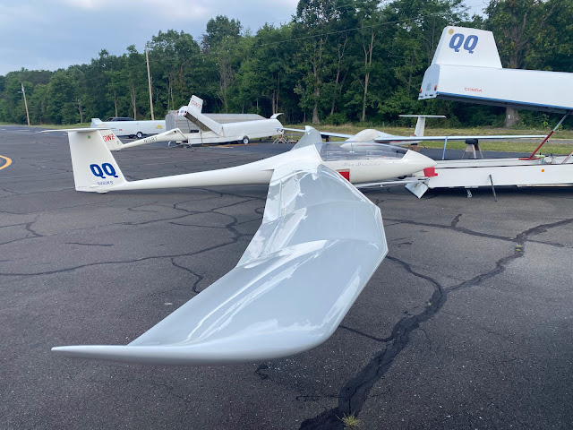 |
| QQ is assembled and ready for flight by 10:00 A.M. |
 |
| Adding 11 liters of water to the tail before takeoff |
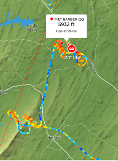
We found some marginal thermals -- one near Gore VA -- that got us closer to the West Virginia border. We headed north and finally found a thermal that gave us a really comfortable altitude of around 6000 feet MSL. The valley in front of us didn't have as wide a selection of suitable landout fields that we can usually find in the Shenandoah Valley. This wasn't treacherous terrain, though.
A few more thermals got us to within gliding range of Potomac Airpark, which is right across the river from Hanover, Maryland. I knew once we had a good altitude over the Potomac river, we could easily connect with the Pennsylvania ridge system.
The winds had been really reducing our speed for all these thermals. For each thousand feet we climbed in a thermal, the wind would push us 5 or 6 miles perpendicular to our course. It would be a really welcome change to have a high ground speed, instead of inching along with thermals.
By 3 PM, we had finally reached the southern end of Dickey's Mountain, and the Tuscarora mountain ridge behind it was sure to be a great ridge run at 100 to 110 knots. It did not disappoint!
We were way behind on my time plan. I was growing increasingly nervous about how we weren't as far along as I had hoped. Back on Friday, when I was planning this flight, SkySight told me that the task was impossible considering the conditions. I was starting to wonder if the software was right!
The task I had planned included one transition to an upwind mountain range. This is a place where I would need a thermal to get high enough to go up wind and connect with Shade Mountain. Unfortunately, by the time we got to that part of the ridges, things were not looking so good. The haze had set in, there was a really thick cloud over that area. We had no idea how the conditions were ahead on Shade Mountain.
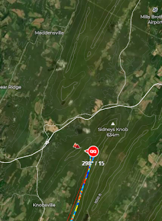 |
| Sat Photo of the terrain for that transition |
 |
| Sat photo of the cloud conditions when we got there |
It just didn't look good. I really didn't want to get stuck on Shade Mountain for the rest of the day. I really didn't want to have to land out at the bottom of one of those mountains. (The fields around here are quite landable, and I would have made a safe landing for sure). We had another 60 miles to go on the ridges to get to the turnpoint. We had another 60 miles to get back. At 100 knots (a very realistic speed), it would take us nearly an hour to get back to this point on the ridge again. And who knows if the conditions are going to allow for a thermal to jump back from Shade Mountain to the Tuscarora?
I decided to turn back. You know, we had already made an excellent trip up here, and the conditions weren't looking that great up ahead. I stand by my decision. Now we just had to get home! This looked like it was going to become increasingly difficult.
We headed south on the Tuscarora back to Dickey's Mountain. There, we would have to find some sort of thermal to get off of the Pennsylvania ridges. The thick layer of clouds above looked like they were going to shut off the thermals for sure. Maybe we will be landing in Pennsylvania, after all!
Once we got to the bottom of Dickey's Mountain, we faced the challenge of climbing up to escape the ridge system. At first, there was no real lift to work. We needed to hang around for a bit to find something strong enough to get us high. The overcast wasn't helping. I took over and performed some figure 8's in front of Dickey's Mountain. We noticed a nice cloud had formed over the track we just flew under. Given the wind strength, there was no way the mountain we just flew along generated that lift, it had to come from a source upwind.
I took the glider upwind on the other, smaller ridge, and found a great strong thermal to get us out of that mess. By the time we got out, the thermal had gotten us from 2900 feet to 5300 feet, and we had made our escape to the East.
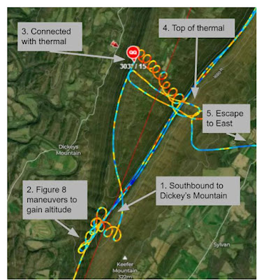 |
| Our escape from Dickey's mountain required a strong thermal on the upwind slope |
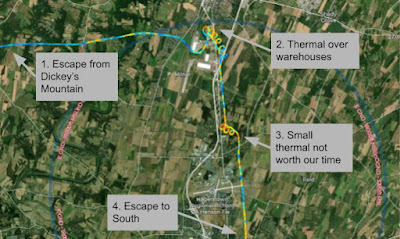
We found a thermal to the south of Hagerstown, MD. It is very likely that this thermal was generated by the Maryland Correctional Institution, or the Roxbury Correctional Institution. By looking at the circles we flew, it sure does look like the solar panels they have in the southwest part of that property are what kicked off that thermal.
Somewhere around here, I suggest that the thermals haven't been that good lately. Maybe we should dump the water ballast so we can work the weaker thermals. Of course, once we dumped the water ballast, the thermals got much stronger. We dumped the water at 16:23, according to the flight logs. Four minutes later, we find a great thermal right over the Potomac River. We climbed from 2600 feet to 5640 feet in a matter of 10 minutes. I had some time to look at the scenery, and I noticed some kayakers on the Potomac river below. It had been over four hours since we took off, so I took advantage while Nelson was flying. Nelson was doing the circling while I was... uh... dumping my own water ballast. Sometimes it's really good to have two pilots on-board for these long flights.
Things started getting easy again. We had escaped the overcast yucky skies to the north, and the thermal clouds are looking better. The visibility was improving. I could just barely make out the Massanutten mountain at Signal Knob about 15 miles away.
"Do you really want to land back at Front Royal, or do you want to run the ridge again?"
Of course Nelson said, "Yeah! Let's run the ridge again!"
We made Signal Knob at 2400 feet MSL, just slightly higher than the mountain. Yep. The ridge was working, and it was working well. Unfortunately, we didn't have any water ballast, so this ride was a bit rougher than the ride along the Tuscarora a few hours earlier.
Nelson did the ridge run southbound, and I took over once we passed the turnpoint at Laird's Knob. On the way back northbound, Nelson got out his iPhone and started recording. We had a great video of the glider's shadow on the mountain. As we approached Route 211, I spotted some hikers on the Yellow Cliffs Mountain Overlook.
While I'm doing all the flying, Nelson made a time-lapse video of the ridge run on the northern part of the Massanutten. You can see from this video the transition across Short Mountain.
We safely landed after 6 hours and 48 minutes of flying. What a day!
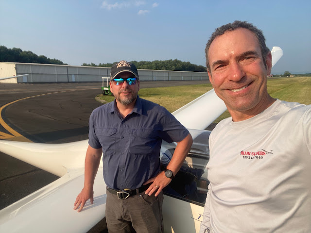 |
| Piet Barber (left), Nelson Brandt (right) after almost 7 hours of flying |
I'm happy that the ground crew stuck around to help us put the glider away. We spent another 45 minutes cleaning the wings, taking the wings off, putting the fuselage back into the trailer. I wear a special apron when I'm assembling and disassembling the glider.
 |
| Another safe put-away after a day of soaring! |
Post Flight Analysis:
- When we were coming back, I don't know why we didn't use the Blue Ridge Mountains to the east to ridge run back to VA. We probably could have spent an hour less time circling over Hagerstown, Martinsburg, Winchester. The transition back upwind to Signal Knob might have been challenging. On the other hand, we could have continued down on the Blue Ridge until we got to Interstate I-64.
- I think the next time, I'll spend more time looking at the ridge lift near Berkeley Springs, WV. I think we could have cut down on some of the thermal time by doing some ridge lift before jumping across the Potomac River.
- In retrospect, it looks like the clouds just beyond the jump to Shade Mountain meant that we could have very easily continued the journey to Snook (our intended waypoint). I didn't know this at the time. Maybe we should have pulled up the sat photo on ForeFlight before making the decision to turn back.
- I need to clean the canopy before flying next time. I can see dust accumulated on the canopy in the GoPro videos.
- I really need to find a better way to mount the GoPro in the cockpit. A lot of the GoPro footage was ruined by Nelson's big hat.
- Nelson flies with a hat in his lap to keep the sun off of his hands. That's weird, and makes the video of him flying look weird. Why is your hand under your hat in your lap? Sheezh.
- Nelson and I get along really well in the cockpit, and have similar thoughts on the decisions we make.
- I'm getting better about only turning to the left when I thermal. Doing right hand turns really helps with the GoPro footage when the camera is mounted on the right side of the canopy.
- I have figured out how to find when the flight computer records the change in mass due to dumping the water ballast. Just do a search for the word "wet" (in lower case) in the IGC file.
- The next time I do a plan like this, maybe I should stay on the Tuscarora ridge, instead of doing the difficult transition to Shade for no appreciable difference in miles.
- We had the 11th highest score in the US for Saturday. We had the highest score east of the Mississippi River. All of the other OLC pilots in the USA had flights out of Region 9 or Region 12 (Warner Springs and Parowan)


No comments:
Post a Comment