This May, I participated in the 20 meter multi-seat national soaring competition held in Mifflin County, Pennsylvania. I drove the mighty QQ to Mifflin on the evening of Mothers' Day. I drove to Pennsylvania with Uwe Jettmar. Erik van Weezendonk arrived on the following day. The contest was scheduled to take ten days in total.
Practice day:
Monday was a practice day. that meant that all of the participants had the option to fly their glider at the airport where the contest was about to take place. The contest director determines task, and all participants arrive at the runway on a first-come-first-served policy. The conditions were weak, but I decided to attempt the task anyway.
Practice Day Task Layout
Erik was not due to arrive at Mifflin until about 1 pm. Uwe and I assembled QQ with the help of another contestant. We left the trailer hooked up to the pickup truck, as we set out on the task. The task was a large area to the northwest (Nisbet), and another large circle to the west of Mifflin (Kettle Dam). The soaring conditions were weak. We managed to get to the first turnpoint. After that, there wasn't much lift. We limped along the Nittany ridge, hoping for some better opportunities to get higher. As we approached State College, I elected to do an off-airport landing at the largest field I could see. The land-out was uneventful. We landed in a cornfield that appeared to be fallow. Erik arrived a short time later, and the retrieve was uneventful. Because of the loose soil we landed in, we elected to leave the trailer on a gravel access road, and tow the glider out of the corn field with a long rope attached to my pickup truck.
I tend to land out at every contest. I suppose it's good to get this out of the way early in the contest. Much like the importance of pre-season games in the NFL, my standings aren't harmed by landing out on the practice day.
Today was Erik's turn to fly. The task was originally set to be a 3 turnpoint assigned area task, but once the fleet was airborne, the task advisors suggested we move to the stand-by task. This task had a 15 mile turn area to the south, Orbisonia, and a 15 mile turn area to the northeast, Shade Mountain.
The beginning of the task had strong lift in thermals. There were no reliable marker clouds to work with, and there was a pall of overcast over most of the area. Once we got started, I climbed to what felt like wave lift above 6500 feet. Unfortunately, the start line had a maximum altitude of 6000 feet. I flew at high speed to the start line, got just under the maximum altitude for the start line, and couldn't get back into the wave lift. For the rest of the day, I spent it hoping to get high enough into the wave.
We tiptoed too much. I ranked 13th out of 15 contestants for the day. The winds were lined up to work the ridge to the southern end of the task area. I never made use of ridge lift. That definitely could have helped my speed on task. We never got low, and I never got desperate, but the pain of how poorly we showed up on the scoresheet reminds me that everybody at this contest knows how to fly faster than me.
This is the day we were all waiting for, and the reason we drive to Mifflin. Central Pennsylvania has an intricate network of mountains that are perfect for glider racing. Depending on the wind direction, you can zoom along at treetop height, connect with other mountains to cover hundreds of miles.
Day 2 was one such day. The winds were predicted to be coming from the north for the whole day. The winds were not so strong that thermals would be disrupted. The weather-guessers predicted all kinds of adventures with good ridge, good thermal lift for the whole area. The task advisors came up with a suitable task that included a trip across the Susquehanna River into Northumberland, PA.
I started across the start line near Lewistown, PA. I set out to the first turnpoint from the maximum altitude, cruising at 110 knots until I got down to ridgetop height along Shade Mountain. Karl Striedieck and Sarah Arnold passed me on the way to the mountain. I kept them in sight as we both zoomed along Shade Mountain. The northern part of Shade mountain is more rounded than the area where we started. We had to slow down to maintain position on the ridge. We found a great thermal, and got enough altitude to make it across the Susquehanna river and to the next set of mountains near Northumberland, PA.
Karl was gone, but a speck of dust in the distance. I could barely see that he had enough to get to the top of the mountain across the river. Uwe quietly watched me cruise across the river and intercept the next mountain ridge with just the right amount of altitude. I went into the turnpoint as far as I wanted to venture, and turned back to jump across the Susquehanna River again. I passed a dozen gliders travelling on the ridge. Since both gliders were going more than 100 miles per hour, the closing speed was about 200 miles per hour. Jim Frantz of New Castle, VA was flying his Ventus 3. It was equipped with a strobe light on the nose which made him quite conspicuous! I need one of those!
When I got to the Susquehanna river, there wasn't a good enough thermal to make it out of there. I hung out with one of the Standard class guys for a while, as I saw other 20 meter gliders show up and try to dig out.
Eventually, I found a nice enough thermal to get away from the ridge. I headed directly to Penn Valley airport just-in-case. Strangely, I found a thermal right over the river. It was enough to get us the altitude we needed to get back to Shade Mountain.
I followed Shade Mountain until just after Lewistown, PA. At that point, the ridge turned unfavorably, so that the winds would no longer support ridge soaring along that part of the mountain. I headed back upwind to get back to Shade Mountain (the third turnpoint). Heading south again, my next challenge was to find a thermal to make it upwind to Jacks Mountain, near Mifflin. It took me longer than I wanted, but I made it with plenty of altitude to spare. Once on Jacks Mountain, I took the ridge as far as I could muster. Jacks Mountain will work with a northerly wind, but not much past a point called "Mill Creek" It was there that I turned around and headed back home.
I was proud of my accomplishment until I saw the score sheet. I placed 11th. Man, I suck at this racing thing. Maybe I will enjoy this contest more if I just stop looking at the score sheet.
The task originally called for a racing task. The thermal conditions weren't as good as predicted, so the task advisors suggested we go with an Assigned Area Task instead. Erik was co-pilot.
I spent 1.5 hours in the start area, waiting for the conditions to be strong enough to get on-course.
We headed toward Shade Mountain, transitioned to the Tuscarora, came back, flew the backside of Jacks Mountain until the ridge turned to the south to a heading where the winds would no longer hold us up. I returned, never having any real problems, and never getting really low. Somehow we managed to place 5th for the day.
I got some great in-flight footage with Papa Lima while flying on the backside of Jacks Mountain.
The winds were pretty much right out of the south. This was a rare day when we both have enough convection for thermals, and we have a southerly wind strong enough to fly in Jacks Mountain.
After starting, I follow the pack northward toward the northern end of Jacks Mountain. The task requires us to get upwind to Shade Mountain, but the conditions didn't look like I could make it. Once we got to the end of the mountain, we went north a bit more, but the thermals weren't quite there yet. I headed back south, and flew in formation with Hotel-Hotel out of Haris Hill. I had Erik take some GoPro footage of HH in flight. That video turned out great!
Somehow we managed to take 5th place for the day. I've moved up to 8th place overall.
On Day 6 the winds were much more favorable for most of the ridges in the area. The task called for a much longer trip, covering far more miles. We started the day early with an earlier-than-usual launch time, but it didn't make much difference. I spent an hour in the start area, trying to get enough altitude to get into the start line.
Day 5 covered the most ground
I finally got past the start line and headed due-south to Shade Mountain. I cruised somewhere between 100 and 105 knots at tree-top levels. The glider was fully loaded with water for maximum speed. We got to the southern end of Shade Mountain, where several gliders circled around, trying to get enough altitude to get to the Tuscarora mountain. Some of the heavier gliders turned back, noting that they don't soar very well with the weaker ridge conditions. I headed south for some more easy speed points.
I followed Papa-Golf and Hotel-Seven along the ridges until the very end of this mountain chain, at a place called "Dickie's Hill." This part of the mountain chain is very close to the Pennsylvania - Maryland border.
Heading back north, I got stuck on the transition from Tuscarora to Shade Mountain. I had been slowing down so I could get high enough to make the jump without circling. This was a dumb strategy, as I ended up at the same altitude anyway, but doing it much slower.
Karl Striedieck passed me at this point; maybe 500 feet below me. Apparently, he knows the exact altitude it takes to do the Tuscarora-Shade jump. I followed him, along with Papa-Golf and Hotel-Seven.
Karl passed Papa-Golf, but I couldn't quite bring myself to fly close enough to Papa Golf to get past him. By the time we got to Lewistown, PA, we had to make a reasonably-sized jump upwind across the Juniata river.
At this point, we had to make a long upwind trek to White Pine. I found what I thought was a good cloud street, and stopped to climb in a thermal. Papa-Golf kept going along Shade Mountain. Hotel-Seven circled with me up to about 6000 feet. I thought Hotel-Seven and I were going to hang-out, but he went further down the mountain to hang out with Papa-Golf. I started to find thermals, and tried to street upwind. We were never low, and never in jeopardy of landing out, but it took forever to fight the headwind. I touched the turnpoint and headed downwind.
The flight computer is telling me I'm slow. I know I'm slow. We are on track to finish the task on time. I'm annoyed about how long it took to go upwind toward Nisbet, so I'm looking for some fast-tracks to absorb out some of that slow flying I did. I see a magnificent cloud street toward Mid-State airport. The flight computer tells me that I will be well over-time when I arrive at the finish line. Oh well.
I fly alongside Karl Striedieck along Jacks Mountain. In fact, I even passed him at one point. Right after I passed him, I found one of the weaker parts of the ridge, so I slowed down, and went upwind to "the step" along Jacks Mountain.
I was too low to see that Erik had applied a bag of lime to a road that crossed over the peak of Jacks Mountain. He painted "QQ" in big bold letters. Unfortunately, I never saw it, as I was too low, and didn't have the right angle to see it. The rest of the pilots saw it, though!
I ranked 15th for the day. Holy crap I really suck at this. I think about that scene in Caddyshack with Chevy Chase and Rodney Dangerfield, "You're uh... 'not good'." I have no idea how everybody else was 7 miles per hour faster than me. I'll have more fun if I stop looking at the scoring sheet. I'll have to do an analysis of the flight logs of everybody else to see why I suck so bad.
This was a day that featured no ridge soaring. The thermals were strong, and there were streets everywhere. Day 6's task didn't have large turn areas. Instead, we had to get within 0.3 miles of each turnpoint. This meant that we all had a good understanding of how well we are doing, relative to everybody else. Days 1 through 5 were Assigned Area tasks. For those tasks, the competitors go figure out the course they think will get them the most points. Nobody knows how well they did for the day until the score sheet is posted.
Day 6's task looked like a capital W. I followed the clouds as best as I could. I thermalled when it was good, I never got low, I passed up on marginal thermals. I flew over the Raystown Dam. I saw a glider in the distance, circling, and I headed toward that spot he was thermalling. I kept up with all of the gliders that had caught up with me at the first turnpoint.
Starting early really hurt me, and we ranked 11th for the day. Somehow, we've moved up in the rankings, and we in 8th place overall. It's not that we're doing well, it's just that some of the other pilots who did well on other days landed out or withdrew.
I really like the racing tasks. I don't have to think too much. I just show up, fly to the waypoints, try to find a way to the next waypoint. If I could choose, we would have nothing but racing tasks.
I was the first to start the task, and I headed directly Across Seven Mountains on the way to White Pine airport. To me, the day felt like it was going to abruptly end. Spending time with start-line games felt foolish. Especially since I'm so slow, as evidenced by the scoresheet.
In retrospect, it might have been dumb to start as early as I did. Everybody who started later got to analyze exactly where I was circling. They could see me really clearly because my glider has a transponder and ADS-B. I spent more time at the slow part of the task.
By the time I just passed the first turnpoint, everybody in the 20 meter class caught up with me, or passed me. Well, we all established by the scoresheet that I kinda suck at this racing thing. It sure was a nice day to fly, though.
The next turnpoint was MidState airport, which is also on the Appalachian plateau. There are almost no landable fields directly between these two turnpoints. I spent time with Hotel-Hotel for a brief while. At some point, he went right, and I went left.
Hotel and Hotel-Seven met up with me and we traded spaces for a while. They would find a good thermal to work, while I pressed on. When I found a thermal I liked, they would join me.
We got slow and worked on weaker thermals as we approached the southwestern-most point. Unfortunately, I didn't keep with the pack, I went right, when the pack went left. I really suffered for this. Everybody left me behind. We limped north to Penns Cave. The sky looked really bleak. I made the turnpoint. We haven't seen a good thermal in a long time. There is a huge deck of overcast
and made it home without ever really being desperate for altitude. I don't know how I managed to take 6th place.
I can't believe we've had this much great weather. To have a contest with 8 flyable days is utterly inconceivable to me.
We were on grid position 24. There was only one glider launching after us. By the time we were off tow, all the other gliders had climbed several thousand feet, nearly to cloudbase.
After getting off tow, I couldn't find any lift. We scrounged around for a morsel of lift, but found nothing. I landed at Mifflin, came to a stop. Within 30 seconds we were back in the air behind the same tow plane as before. "Don't tow me to where you dropped me off last time." He dropped us off where we released last time.
There was no improvement in the soaring at that location. In the time it took for us to land, take off again, release from aero tow, the fleet had started the task.
I was left scrounging around looking for some lift in the start area. I found a thermal right over the airport. I climbed to 6400 feet MSL, and headed through the start line, on course.
I'm pretty sure Hotel-Hotel and I were the last ones on course. I looked at the flight computer to see if there was any of the fleet in front of us. They were all specks in the distance. We're so far behind, we're so screwed.
I turned left near University Airpark airport at State College, and follow the Tussey Ridge. Tussey has thermals popping off of it. The flight computer insists that the winds favor the ridge. Eventually, we get down to ridgetop level and find that Tussey is indeed working. Not working really well, but we are maintaining 80 knots along the mountains, well south of Spruce Creek.
Papa-Lima is on the ridge with us. We notice some of the pack of gliders flying overhead. Everybody is high except for Papa-Lima and us.
At the southern end of the turnpoint, we expect Papa-Lima, who is slightly ahead of us on the ridge, to turn around. They did not. Instead, they turned left. They went downwind off the ridge to some questionable terrain downwind. Questionable unlandable terrain with a lake and a smaller ridge. "Nope. Not following them!"
We turned back north, slowed down to get some altitude, and waited for a strong thermal to connect, so we could climb high and move on to the next turnpoint.
We found a great 8 knot thermal and climbed to over 6500 feet. We set out downwind. There were several mountains in sight ahead of us that would have worked great. I elected to use Shade Mountain. We could go up Shade Mountain and use ridge lift along the way. Hey, ridge lift has been working so far, right?
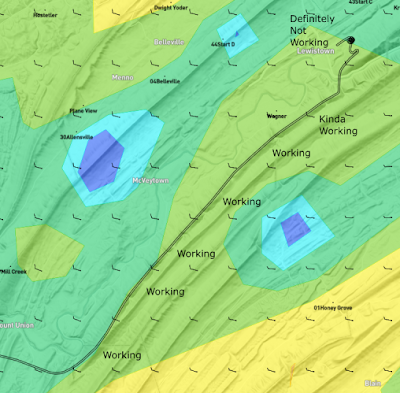
The image above is a view of SkySight's predicted winds at 2000' MSL (approximately the top of the mountain). The lines indicate a wind from the west. Each barb is either 5 knots or 10 knots of wind. Our flight track along Shade Mountain is shown with the black line. Our path was from the bottom left of that diagram to the top right of the diagram. I've marked my opinion about how well the ridge was working for us along the way. "Working", "Kinda working", and then finally, "Definitely Not Working"
After making the transition across the Juniata river, the northern portion of Shade Mountain was "Definitely Not Working" and we were looking for a place to land. There were no thermals to work with, since an overcast sky blocked out all the sun.
We came in 12th place that day. Papa-Lima, the one that took that bad left turn at Altoona, ranked 13th for the day. They never got off of Raystown ridge, and did a landing at an airport much further back on the course than we did.
I had the GoPro running while we were deciding which field to land in. This could be a valuable resource if you've never seen an off-field landing in a glider before.
Unbelievable! We had 10 days available for soaring, and we flew on 9 of them.
The only way we're going to place in this contest is if we are the only ones to make it around, while everybody else lands out. This isn't going to happen. Instead, I decided to have a lazy fun day, and my average speed showed it. We came in dead last (11th place) for the 20 meter multi-seat class. This flight wasn't particularly remarkable, so I won't go into much detail.
Strangely enough, we had come in sixth place overall. All of the other competitors who ranked lower than us had made more mistakes than we did.


No comments:
Post a Comment